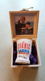
These are items from the estate of maritime artist Michael Ralph who was there for the 1996 expedition to the Titanic during which they recovered multiple artifacts including the Big Piece.
This brochure details the dives and schedules for people planning to join the expedition.
These ship blueprints were handed out one of the ships participating in the 1996 expedition which show the layout of the different decks of the ship.
This photo mosaic is one of 4 printed off and handed to crew members of an expedition before they went down to the wreck site they used them at the wreck site for reference points as they explored and decided what to recover. The photo mosaic is of the debris field near the stern section with notes pointing out different artifacts.
This is a really cool piece. It's a Reaserch & Recovery Expedition 1994 - Dive Plot. The plots are real time tracking for every dive on the wreck site and serve as a recorded archive. Transducers are dropped on the seabed, triangulating the wreck site, it is these instruments that determine the location and orientation of the submersible, which are combined with the relative position data from the SBL system to establish the position of the tracked target in earth coordinates, through Satellite orientation via the Mother ship, the Nadir. A short baseline (SBL) acoustic positioning system is underwater acoustic positioning systems that are used to track underwater activity and routing of the submersible, Nautile. A typical mission of a site will span several dives, as tasks such as initial investigation, still image acquisition and video transects are gradually completed. A critical element in these dive series is to show prior-dive search coverage, so that a successive dive can be targeted at a previously unvisited area. This is done by producing a cumulative coverage plot of the dive site. The plot, which is updated during and after every dive, is displayed as a background map on the navigation screen thus providing guidance for the ongoing dive. The precise plot and coordinates are then cross referenced with crew dive logs, to precisely place and record the recovered location of an artefact, archived in the artefact seabed archeological database. The plots also serve as a safety tracking system should communications are lost with the Nautile during a dive.
In order to reach the wreck of the Titanic, it takes descending about 12,500 feet to the wreck site. To demonstrate, the great amount of pressures down at the bottom of the sea, styrofoam cups such as this were attached to the submersibles and brought down with them. As they descended to the wreck site, all the air was squeezed out reducing the cups to sizes and shapes much different from what they were previously.


No comments:
Post a Comment